Codorus Creek Watershed Association

Water Resources

Home
Creek Cleanup Photos
CoCoRaHS
Reports
Current Weather
Contact CCWA
Who We Are
Watershed
What We Offer
Join CCWA!
Calendar
Get Involved
Links
Photos
Barshinger Creek Photos
Nursery Photos
Water Resources
Thematic Maps
Water Quality
Water Pollution
Effects of Pollution
Mining
Agriculture
Forestry
Septic Systems
Urban Land Use
Hydrologic Alteration

About Codorus Creek

The Codorus Creek Watershed is home to over 200,000 residents who live, work and play here. Codorus Creek drains 278 square miles of southwestern and central York County, Pennsylvania, with over 447 miles of streams, three major reservoirs, and many more ponds and wetlands.
 
Clean water is used for agriculture, industry, drinking, and recreation. Biodiversity includeds a range of native and invasive flora and fauna. However, Codorus Creek and some of it's many tributaries are impaired by nonpoint sources of pollution: sediment, nutrients and toxic substances.
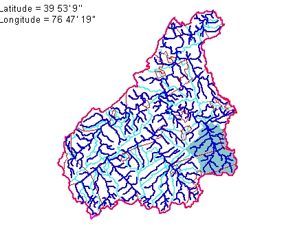
Background

  • Location: York County, south-central Pennsylvania
  • Source: West Branch, West Manheim Township (near Linesboro, Maryland. Elevation 1,020 feet above MSL.
  • Outfall: Susquehanna River (near Saginaw). Elevation 241 feet above MSL. Latitude 39 53'9". Longitude 76 47'19".
  • Course: Southwest to northeast
  • Drainage Area: 278 square miles (177,920 acres)
  • Length: 48 miles
  • Meander Ratio: 1.18
  • Relief Ratio: 16.2
  • Slope: 6.0 feet/mile

Physiography

  • Piedmont Province
    • Piedmont Uplands section (source)
    • Conestoga Valley section (outfall) 
  • Drainage pattern dendritic 
  • Channel pattern regular 
  • Topography 
    • Upper and middle reaches rolling hills, broad valley, moderate slopes
    • Lower reach hills, narrowing valley, moderate to steep slopes

Population & Land Use

  • Population 205,000 (2000)
  • Growth Rate ~12.4%
  • Lands Use
    • 42% Cropland
    • 14% Pasture
    • 26% Woodland
    • 18% Urban

Codorus Watershed Map

Codorus Watershed
codoruswatershed.jpg
West, South, East Branches, and Codorus Creek

Geology & Soils

  • Chester-Glenig-Elioak association: Deep and moderately deep soils underlain by schist and phyllite
  • Glenig-Manor association: Shallow and moderately deep, mostly modertaely sloping to moderately steep soils underlain by schist or phyllite.
  • Cardiff-Whitford association: Shallow and moderately deep soils underlain by slate, hard shale or hard phyllite
  • Hagerstown-Duffield association: Deep, nearly level to modertaely steep soils underlain by limestone
  • Conestoga-Duffield-Bedford-Lawrence association: Deep and modertaely deep soils underlain by impure limestone or clacareous schist
  • Edgemont-Highfield-Murrill association: Deep upland soils underlain by quartzite, aporphyolite, quartz, or metabasalt; and deep colluvial soils over limestone

Natural & Recreational Resources

  • Reservoirs
    • Lake Marburg (1,275 acres), fishing, swimming and other uses
    • Lakes Williams/Redman (~400 acres), fishing, drinking 
  • State Parks
    • Codorus State Park
  • County Parks
    • York County Rail Trail
    • Spring Valley County Park
    • William Kain County Park
    • Nixon County Park
    • John Rudy County Park
    • Rocky Ridge County Park
  • Fishing
  • Canoeing & Kayaking

Copyright 2015  --  Codorus Creek Watershed Association (CCWA)